Rail Alignment and Benefits (RAB) Study
Formerly Railyard Alternatives and I-280 Boulevard Feasibility Study
FINAL DOCUMENTS POSTED: the documents below have been updated to reflect comments received at various meetings and through correspondence.
- Final Executive Summary Report September 2018
The full Technical Report is available below.
Got 6 minutes and 40 seconds?
Watch the RAB Pecha Kucha presentation given at SPUR or see the slides here.
About the Study
The Rail Alignment and Benefits (RAB) Study is analyzing the best ways to bring Caltrain and High Speed Rail to the Salesforce Transit Center while connecting San Francisco's fastest-growing neighborhoods on the east side of the City.
To coordinate and support efforts of Caltrans, Caltrain, High Speed Rail, the Transbay Joint Powers Authority, the RAB Study includes 5 components:
|
Study Components Map |
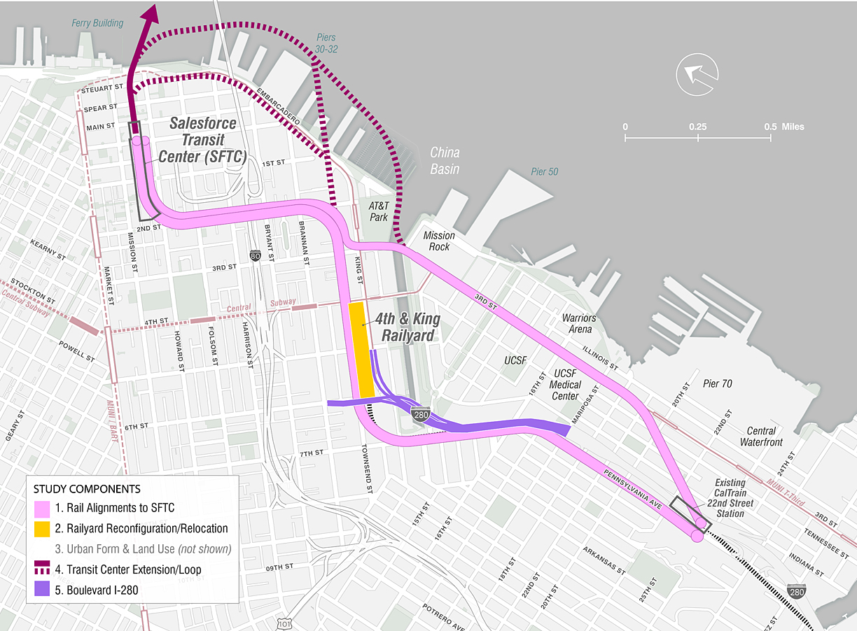 |
1. Rail Alignment into the Salesforce Transit Center (SFTC)
This component seeks to answer the most time sensitive question of the RAB: how to bring both Caltrain and High-Speed Rail from the county line into the Salesforce Transit Center.
2. Railyard Reconfiguration/Relocation
This component considers reknitting the fabric of the City by modifying or relocating some or all of the activities at the 4th/King Railyard.
3. Urban Form and Land Use Considerations
Relocating the Caltrain Railyard and/or other infrastructure changes could make new land available for the restoration of the street grid, improved bike/pedestrian connections, elimination of rail hazards and noise, and construction of housing, commercial development, and open space. This component considers these issues at a conceptual level and provides a baseline for future study.
4. Transit Center (SFTC) Extension/Loop
This component explores future scenarios for train connections and operations beyond the initial connection to the SFTC to improve station capacity and/or rail connections beyond SFTC to the East Bay or back down the Peninsula.
5. Boulevard I-280
This component analyzes the interaction between proposed rail alternatives and the I-280 structure to ensure that the rail alignment does not preclude the possibility of future changes to I-280 north of Mariposa.
Schedule and Next Steps
- Phase I (2014-2016): Preliminary Analysis
- Phase II (2016-2018): Alternatives for Consideration
- 2018: Select preliminary preferred alignment
- 2018+: Coordination and follow on work with partner agencies
Public Meetings
May 29, 2018: Public Meeting
A public meeting was held to summarize the findings from the RAB study, including a preliminary preferred alignment for Caltrain and High Speed Rail: the Pennsylvania Avenue (DTX + Extended Tunnel). Community members were invited to provide input on the alignment, adjacent land use opportunities, and next steps. Provided below are the materials that were presented at the public meeting (additional materials will be added at a later date):
- Presentation
- Boards and Handouts
- Rail Alignment and Benefits Study:
- Final Executive Summary Report September 2018 (Planning Department)
- Final Consultant Technical Report
- Appendix A: Conceptual Design Drawings, Alignment Alternatives
- Appendix B: Conceptual Design Drawings, Loop Alternatives
- Appendix C: Operations Analysis (RAB Operations Sketch Planning Analysis)
- Appendix C: Operations Analysis (Conceptual Planning Analysis)
- Appendix D: Economic Analysis of Rail Alternatives ( Land Value Analysis)
- Appendix D: Economic Analysis of Rail Alternatives (Financing Opportunities)
- Appendix D: Economic Analysis of Rail Alternatives (Secondary Costs Analysis for RAB Alternatives)
- Appendix E: Basis for Comparative Cost Analysis
- Appendix F: Traffic Analysis, I‐280
- Appendix G: Rail Relocation Land Use Analysis
- Appendix H: Additional Technical Analysis – Soil Conditions & Geologic Hazards, Tunneling, and Fire Life Safety
- Appendix I: Index to Document Library
March 28, 2018: Citizen Working Group - Meeting #6
February 23, 2016/March 30, 2016: Community Discussion on the first phase of the Railyard Alternatives and I-280 Boulevard Feasibility Study
- Presentation
- Poster Board - comments collected at meeting
- Poster Board - questions and answers collected at the meeting
- Fact Sheet
Interested in hearing from a Citizens Working Group (CWG) member?
- Click here to read an article from Ron Miguel, chair of the RAB Citizens Working Group.
- For more information on the CWG including meeting dates and materials, click here.
Funding
The study currently has received approximately $1.7 million through the following:
- Two MTC Priority Development Area (PDA) competitive planning grants of $519,940 (Phase I) and $700,000 (Phase II)
- Strategic Growth Council (SGC) Sustainable Communities Planning grant of $490,672 (Phase II)
- Planning General Funds $325,000 for additional rail operations sketch modeling, additional quantitative and qualitative analysis, and outreach (Phase II)
Agency Coordination
The study has a technically advisory committee (TAC) which includes representation from Metropolitan Transportation Commission (MTC), Caltrans, California High Speed Rail Authority (CHSRA), Caltrain, Transbay Joint Powers Authority (TJPA), California State Transportation Agency (CalSTA), Federal Transit Administration (FTA), Federal Railroad Administration (FRA) and various City and County Departments including: San Francisco Planning, San Francisco County Transportation Authority (SFCTA), San Francisco Port Authority, San Francisco Municipal Transportation Agency (MTA), San Francisco Department of Public Works (DPW), San Francisco Office of Community Investment and Infrastructure (OCII), San Francisco Office of Economic and Workforce Development (OEWD), and San Francisco Mayor's Office.
The San Francisco Planning Department has contracted with international engineering firm CH2M Hill to aid the City in this effort.
Contact
For comments or suggestions related to this project, please contact:
Jeremy Shaw
San Francisco Planning Department
(415) 575-9135
jeremy.shaw@sfgov.org