Zoning Maps
Updated
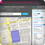
Nightly San Francisco Property Information Map
Public access to useful property data
Enter search criteria for a case number, street address or parcel number and view reports for that property.
Example of reports include: Property (build date, sales price, land value, parcel number etc.), Zoning, Preservation, Applications and Permit histories, etc.

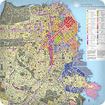
Jan 2018Zoning Map – Height/Bulk Districts
Map of the City height/bulk Districts.
Details on purchasing a printed poster of this map can be found here
Map of the City height/bulk Districts.
Details on purchasing a printed poster of this map can be found here
Updated
Quarterly
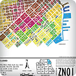
Zoning Map – Zoning DistrictsQuarterly
A color-coded, single-document map (PDF) of the City showing Zoning Districts.
Details on purchasing this map can be found here.
Updated
As Required
Zoning Maps per Planning Code §105 and §106 As Required
Published online by American Legal, the City's code publisher
» Zoning Use District (ZN)
» Height & Bulk District (HT)
» Special Use District (SU)
» Preservation District (PD)
» Coastal Zone (CZ)
» Special Sign District (SS)