WalkFirst Phase 3: Streetscape Prioritization
Introduction
San Francisco's streets represent 25% of city land. Streets are our most important public resource, in large part because they are shared equally by all residents of San Francisco. Our streets are not just about transportation, but also recreation, social and economic activity, and ecological performance. The way in which we design our streets can help support these activities.
Over the years our streets have been transformed through efforts such as the Great Streets Project and the 2011 Road Repaving and Street Safety Bond, using the Better Streets Plan as a guide. These projects enhance the public realm, improve the transportation function of the street, and create other economic, environmental and social benefits.
Streetscape Projects
Streetscape projects improve the street environment for all people by providing space for mobility, social and recreational activities. Streetscape projects enhance the aesthetic and ecological qualities of the street, improve safety, and enrich the street's character and identity. Streetscape projects could include improvements such as sidewalk extensions, street trees, sidewalk landscaping, green infrastructure, street furniture, pocket parks, and other amenities.
The specific project elements will depend on a number of factors including the project budget, existing conditions of the street and community feedback. Below is a table which outlines the types of improvements you might see, depending on the specifics of the project.
Very Light Complete Street Enhancements
Description: Includes a mix of pedestrian and bike enhancements and greening elements, but would potentially not include full list of enhancements desired by the community (e.g. separated bike lanes, sidewalk widening)
Potential Scope of Work: Infill street tree planting (there are already many healthy trees on the corridor), bike lane striping, median planting, and upgrades to existing street lights.
Examples: Lower Polk, Van Ness Avenue, San Bruno Avenue, 19th Avenue Median (see image above) and Point Lobos.
Cost Per Block: $100k - $500k
Light Complete Street Enhancements
Description: Includes a mix of pedestrian and bike enhancements and greening elements, but would potentially not include the full list of enhancements desired by the community (e.g. separated bike lanes, sidewalk widening). NOTE: To date, most complete streets delivered by the city have cost more than $1M block or did not include repaving.
Potential Scope of Work: Repaving, infill street tree planting (there are already many healthy trees on the corridor), a limited number of bus bulbouts, ADA improvements, bike lane striping, median reconstruction, and upgrades to existing streetlights. Alternatively, this could be complete streets with short blocks such as Leland Avenue and Broadway Street.
Examples: Folsom Streetscape (19th to Cesar Chavez) and the Divisadero Streetscape (see image above)
Cost Per Block: $500k - $1.2M
Full Complete Street Enhancements
Description: Includes substantial street and sidewalk enhancements that result in a more thematic appearance of the corridor.
Potential Scope of Work: Substantial pedestrian and bike improvements (such as sidewalk widening and separated bike lanes), street greening, street lighting, transit station upgrades, and reconfigured traffic patterns.
Examples: Valencia Streetscape (see image above) and the planned Jefferson, Masonic, 2nd Street Streetscape projects.
Cost Per Block: $1.2M - $2.5M
Purpose & Outcomes
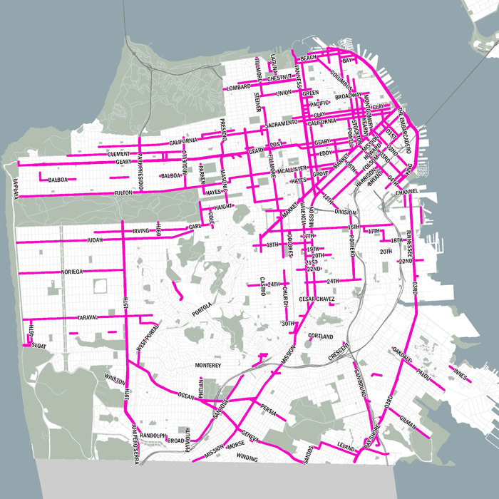
The goal of WalkFirst Phase 3 was to identify where the City should make streetscape improvements to have the greatest benefit, given limited funding. The project first identified a citywide Streetscape Network, representing places where people are walking OR would walk if the conditions were better. The factors used to define these streets include population density, transit ridership, land use, and priority pedestrian streets identified in streetscape plans. To view the specific criteria, click here.
The Streetscape Network was further distilled to a number of Priority Project Locations, segments of the network with high pedestrian activity, poor pedestrian environment and neighborhood commercial-type uses. Funding for streetscape improvements will be prioritized at these locations.
Final Report
This final report documents the methodology used to prioritize locations for future streetscape improvements.
- Final report
- Appendix A1 - Best Practices Report
- Appendix A2 - Prior Plan Methodology
- Appendix A3 - Scenario Planning Technical Memorandum
- Appendix A4 - Database of Streetscape Variables
- Appendix A5- Streetscape Suitability Coordination
Links & Resources
- Better Streets Plan
- Green Infrastructure Projects, SFPUC
- Pedestrian Safety Executive Directive, December 2010
- Pedestrian Strategy, Mayor's Pedestrian Safety Task Force
- Street & Streetscape projects, Department of Public Works
- Vision Zero