South Mission Historic Resource Survey
Overview
The South Mission Survey was conducted by Planning Department staff, with assistance from the historic architecture firm of Page & Turnbull, as one of several planning studies that will be used to inform the implementation of the Mission Area Plan. The South Mission Survey resulted in documentation and assessment of approximately 3,800 individual buildings, including nearly 1,000 individual historic properties and contributors to 13 historic districts. The South Mission Survey included the area that is bounded approximately by 20th Street to the north, Cesar Chavez Street to the south, Potrero Avenue to the east, and Guerrero Street to the west. The South Mission Survey was adopted by the Historic Preservation Commission on November 17, 2010.
For more information regarding the South Mission Survey, please contact:
Tim Frye
Preservation Coordinator
(415) 575-6822
tim.frye@sfgov.org
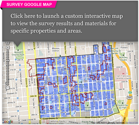
The Department has created an interactive "Google Map" a custom application to navigate around the survey area and find survey parcels. You can view survey results and materials for specific properties and areas. To use the map, click here.
Survey Results
To view specific survey materials listed below, click on the name of a document to view that document. Printed copies are available for review at the Planning Department offices.
Historic Resource Survey Findings
- Map of Historic Resource Survey Findings
- List of Surveyed Properties, sorted by Street Address
- List of Surveyed Properties, sorted by Assessor Block-Lot
Individual Historic Resources
- Map of Individual Historic Resources
- List of Individual Historic Resources, sorted by Street Address
- List of Individual Historic Resources, sorted by Assessor Block-Lot
Historic Districts & Contributors
- Map of Historic Districts and Contributors
- Summary/Description of Historic Districts
- List of Historic District Contributors, sorted by Street Address
- List of Historic District Contributors, sorted by Assessor Block-Lot
- List of Historic District Contributors, sorted by Historic District
Historic Districts (Descriptions, Maps and Property Lists)
- Shotwell Street Victoriana Historic District
- South Mission Avenues and Alleys Historic District
- East Mission Florida-to-Hampshire Streets Historic District
- Horner's Addition East Historic District
- Gottlieb Knopf Block Historic District
- Von Schroeder-Welsh Block Historic District
- 23rd Street Shops and Row-Houses Historic District
- Alabama Street Pioneers Historic District
- Hampshire Street False-Fronts Historic District
- Olsen's Queen Anne Cottages Historic District
- Juri Street Historic District
- O'Donnell-Fowler Homes Historic District
- Orange Alley Stables and Lofts Historic District
Other
- Multiple Property Documentation Form
- City within a City: Historic Context Statement for San Francisco's Mission District
(to be updated based on survey findings)